Faulkner: Take Rural Infrastructure Out of Politics
Federated Farmers' new vice president Sandra Faulkner says the issue of adverse events emergency management and infrastructure needs to be taken out of the three-year political cycle.




 increase font size
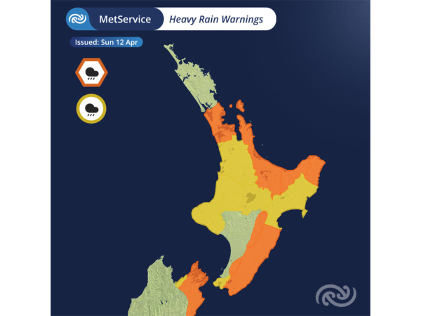 Heavy Rain Warnings are in place for much of the North Island.
Cyclone Vaianu is continuing its track south towards the Bay of Plenty, bringing with it destructive winds, heavy rain, and large swells, says Metservice.
Red Strong Wind Warnings are in place for both Bay of Plenty and Coromandel, with gusts of up to 130km/hr posing risks to life, infrastructure, transport, and power supply.
Orange warnings and watches also extend across much of the North Island.
According to Metservice, at 11:30am Sunday, the centre of Cyclone Vaianu was situated due east of Coromandel Peninsular, tracking southwards towards the Bay of Plenty.
While the centre is still offshore, the strong winds, heavy rain and large swells associated with this system are being felt far from the centre.
Overnight, gusts of over 130km/h were recorded at Mokohinau and Channel Island and 24-hour rainfall totals in Whangārei reached over 100mm.
As Cyclone Vaianu continues to move closer to New Zealand winds are set to increase, especially for regions like the Bay of Plenty and Coromandel where gusts of 130km/h are possible.
A Red Strong Wind Warning remains active in these areas until Sunday evening. Winds of these strengths bring the threat to life from flying items and falling trees.
Destructive winds will cause widespread damage including powerlines and roofs, and significant disruption to transport and power supply.
Strong Wind Warnings and Watches cover the rest of the North Island. Auckland will notice strengthening southwesterlies this afternoon as Cyclone Vaianu moves to the southeast.
Wrapping around Vaianu, bands of rain will bring some larger totals to parts of the North Island and top of the South Island. A patchwork of Heavy Rain Warnings and Watches are in place, with the heaviest rain forecast over the higher ground from the Coromandel to the east coast.
The combination of strong onshore winds, rising rivers, large swells and low pressure increase the risk of coastal inundation especially for the Bay of Plenty and round to Hawke’s Bay. Be extra cautious around the coast, especially around high tide.
Cyclone Vaianu is forecast to cross the North Island today and move between the South Island and the Chatham Islands during Monday. A Strong Wind Watch is in place for the Chatham Islands from 9pm Sunday to 9am Monday.
Federated Farmers' new vice president Sandra Faulkner says the issue of adverse events emergency management and infrastructure needs to be taken out of the three-year political cycle.

The country's kiwifruit growers seem to have escaped much of the predicted wrath of Cyclone Vaianu which hit the east coast of the North Island this month.
While Cyclone Vaianu remains off the East Coast of New Zealand, the Waikato Civil Defence Emergency Management (CDEM) Group says impacts have been felt overnight.
A Local State of Emergency has been declared for the Waikato for a period of seven days as the region prepares for Cyclone Vaianu to hit the area.
Specialist horticulture and viticulture weather forecasters Metris says the incoming Cyclone Vaianu is likely to impact growers across the country.
High country stations, mixed sheep and beef farms, Māori-owned farms, corporates and family operations are among the nine commercial farms taking part in the Livestock Innovation Farming Transformation programme, known as LIFT.
OPINION: New health and safety guidance unveiled by the Government recently provides farmers greater certainty about what is expected of them when managing risks on farm.
The National Animal Welfare Advisory Committee (NAWAC) is seeking public feedback on proposed changes to the Code of Welfare for Rodeos.
A New Zealand initiative supporting farmers to restore the health of grazing landscapes has received international backing through the Regenerative Fund for Nature, a global collaborative fund supporting regenerative agriculture and the communities that produce natural fibres for the fashion industry.
Combine premium New Zealand products, blend in a family ritual and what do you get? A world-class functional drink.
Entries are now open across eleven regions for the 2027 New Zealand Dairy Industry Awards (NZDIA).


OPINION: The same mainstream media muppets that brought you Jacindamania in 2017 have been flat out pimping for the Opportunities…
OPINION: Your old mate reckons the atrocious way farmers in the UK are treated by their lords and masters in…