Northland Study: Emissions Cuts "Unsustainable" for Dairy
A five-year study has found that the cost of reducing emissions without technology may be significant and unsustainable for Northland dairy farmers.

 increase font size
 Modelling as late as yesterday afternoon suggested the cyclone would likely have a significant impact in the Ruahine Ranges.
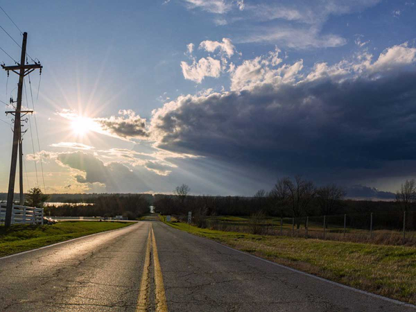
Specialist horticulture and viticulture weather forecasters Metris says the incoming Cyclone Vaianu is likely to impact growers across the country.
In an update to growers released yesterday, Metris says the storm is a very deep low-pressure system likely to be funnel down oveth the North Island by a strong high pressure system off the East coast of the country, a high-pressure system over Australia, and a South Westerly low-pressure system that is converging on the South Island’s West Coast.
Modelling as late as yesterday afternoon suggested the cyclone would likely have a significant impact in the Ruahine Ranges.
What This Means for Key Fruit Growing Regions
Bay of Plenty
The system comes early for Bay of Plenty with the storm winds building Sunday morning, followed by an intense period of wind gusts from Sunday afternoon coupled with heavy rain.
Bay of Plenty copes with rain better than Hawke’s Bay due to its geography and volcanic soils. But forecast high winds and gusts for the Hicks Bay area present the risk of damage to kiwifruit vines from Opotiki through to Te Kaha.
Rain this late in the season has impacts on late season Avocadoes and kiwifruit as it impacts fruit DM. At this stage wind is a bigger risk that growers have more control over, being able to prepare for by checking and securing netting/covers and windbreaks.
Waikato
Blueberries are in full swing with picking in the region. Berries do not like long periods of wet weather. The region’s fast draining soils mitigate some of the rainfall risk. High winds are a risk to net structures and berry growers are likely to have some windfall losses.
Temperatures through Waikato remain warm (circa 20 degrees) which brings a rot risk and can promote bug growth.
The upside of the speed of this system is that by Monday it’ll clear and Tuesday looks to be settled.
Gisborne
While the region is not set to bear the brunt of the storm, it is forecast to see damaging wind gusts over 100kph and between 20mm rain in Gisborne and 100mm of rain in the ranges.
Hawke's Bay
The system is spinning clockwise bringing in rain to the Hawke’s Bay from the East. This will see it dump significant amounts of water into the Waipawa and Waipukurau catchments. Over 130mm is forecast in the Ruahine Ranges which could place pressure on stop-banks.
Rainfall on the Heretaunga Plains is not as heavy with 40mm forecast between Saturday and Monday.
Wind is a larger risk factor for growers and it will rapidly change direction. Wind peaks on Sunday afternoon from the East with gusts up to 80-100kpm. Then, following a brief calm period of approximately an hour, conditions will see a fast swing in direction to a massive westerly as the eye of the storm moves through.
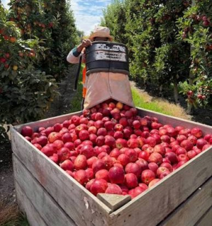
180-degree swings of these magnitudes can be damaging to apple trees as late pick trees will still be under heavy fruit loads and will potentially be waterlogged.
Tukituki catchment growers are at particular risk. Soils should be able to handle 100mm in a 6-hour period, but it will be intense.
It is noted that the last significant rainfall was 21st January where some 80 to 100mm fell across the region. 30mm fell in mid-February. March and early April has been particularly dry with some 20mm-40mm total recorded since the 16th of February and soils are dry.
Wairarapa, Manawatu and Wellington
Grape growers in these regions are forecast to experience significant levels of rain coming from the South-East and high winds as the system funnels moisture up through Cook’s Straight.
Marlborough
Blenheim is likely to catch the edge of the system at this stage with winds wrapping in from the South-East before the system moves out west of the country.
Nelson
Forecasts indicate the potential for Nelson to largely miss out, with only 10-20 mm of rain at this stage as the system moves further East.
Simple Take Outs For Growers and Staff:
A five-year study has found that the cost of reducing emissions without technology may be significant and unsustainable for Northland dairy farmers.

OPINION: With the winter months officially here, I trust all is well at your place.
The country's kiwifruit growers seem to have escaped much of the predicted wrath of Cyclone Vaianu which hit the east coast of the North Island this month.
OPINION: The global crusade against fossil fuel is gaining momentum in some regions.
Cyclone Vaianu is continuing its track south towards the Bay of Plenty, bringing with it destructive winds, heavy rain, and large swells, says Metservice.


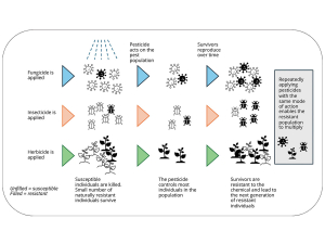
Growers and farmers are being encouraged to have an important conversation before the coming season starts: how to prolong the effectiveness of the crop protection tools they rely on.
A new digital assistant is now helping Ballance Agri-Nutrients farmers speed up nutrient information and ordering.
New Zealand apple and pear industry stakeholders are out in force for the annual conference in Queenstown.
Cameron Reed lives between two worlds.
Improving health and safety is about incremental gain rather than a sudden decision, says Leeston farmer and Federated Farmers health and safety spokesman David Birkett.


A fair question has been raised about how member-funded organisations should conduct themselves when taking a public position on any…
OPINION: It really is getting harder to lampoon government bureaucrats when they do such a good job of it themselves.…
![]()