An interactive web tool to help dairy farmers plan and implement plantings along their waterways is getting good uptake, says DairyNZ.
Senior developer for sustainability and land management Matt Highway says the Riparian Planner tool, online for just over two months, now has about 4000 registered log-on users, and about 80 rural consultants and planners are trained to use it.
Highway presented the tool to a popular workshop at the recent SIDE (South Island Dairy Event) in Invercargill.
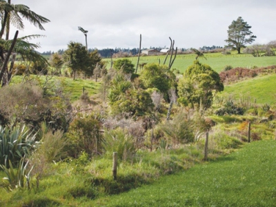
He says the tool enables farmers to examine their waterways on an interactive map, plan suitable plantings and cost the work over the time they expect it to take. The tool can export documentation, for contractors or authorities, if planting plans may be needed under consent conditions.
"If you're a dairy farmer, you put in your supplier number and it'll zoom you to your farm anywhere in the country and allow you to map your waterways and wetlands. And then it asks you what that waterway is like."
The tool will prompt for information on, for example, whether erosion is a problem, and possibly promote that to the top of the priority list. This will allow farmers to plan what they will do and how long it would likely take. Plans might range from merely fencing off grass strips to full planting projects.
Highway says the tool was developed with local experts so that where it suggested possible plant species they would suit the local conditions and be approved by regional authorities.
With 96% of dairy waterways now fenced under the water accord, Highway says the tool will be "the next step" in managing waterways. "This is part of our commitment to New Zealanders towards managing our water quality as well as we can."
More information on riparian plantings is available in regional riparian planting guides, of which 4000 have now been ordered or downloaded directly from the DairyNZ website.