Hail hard on Canterbury crops
Crops across a swath of Canterbury’s arable heartland have been damaged or lost to a couple of hailstorms which swept up the South Island’s east coast late last month.




 increase font size
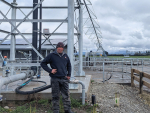
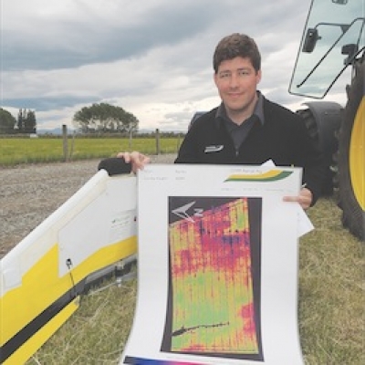 Kris McGillivray with the Ag Eagle and results
ONLY 10-20 years ago the idea of unmanned planes mapping crops was seen as science fiction or the domain of space agencies, but now it’s commercial reality for just $5/ha here in New Zealand.
GHM Aerial Ag’s flying wing traverses paddocks on auto-pilot at about 120m altitude taking near infrared pictures of the crop as it goes. “We just set up the GPS waypoints and it flies back and forth,” explained GHM’s Kris McGillivray.
In a maximum flight of 45 minutes it can cover 120ha. Once downloaded and reconciled into a single image of the paddock or farm the pictures can give early warning of sub-optimal crop or pasture growth, often long before a problem becomes obvious to the naked eye, explained McGillivray.
A more down-to-earth tool also displayed at FAR’s South Canterbury trials site was Smart Ag Solutions’ Veris MSP3 which maps soil pH, texture and organic matter content in one pass (Rural News, March 18). “Basically the ‘3’ indicates it’s three machines put into one,” explained Smart Ag’s general manager Seaun Lovell.
During 12m passes across paddocks a detailed picture of one or more of those characters is compiled, allowing growers to fine-tune inputs such as water and fertiliser according to soil-type, and variably apply lime.
“We’re seeing a lot of history showing up on the pH maps, such as where the spreader has done an extra lap round the headland to finish off the load, or where lime was once stored or where fences and treelines have been removed.”
Even the FAR trial site had a pH range of 5.2-6.6 before lime was applied to correct it. “That’s a huge variation in one 6ha paddock,” he pointed out.
Crops across a swath of Canterbury’s arable heartland have been damaged or lost to a couple of hailstorms which swept up the South Island’s east coast late last month.
This season was among the most difficult for cropping I have ever experienced.
WHEN YOUR spray applications drift they can cause thousands of dollars of damage to neighbouring crops and “there’s really no excuse,” says a US scientist now working in New Zealand.
With close to 24,000 hectares of vineyards in Marlborough, the time is right to identify just what is planted, and where. That’s the view of Wine Marlborough’s GM Marcus Pickens and Cloudy Bay winemaker, Nick Lane.
CROPPING FARMERS in Canterbury and North Otago face a soggy battle to get winter cereals sown after another belt of rain swept the region this week.


Dr Scott Champion, Foundation for Arable Research chief executive, says that everyone in the supply chain had a role to play in driving the sector's long-term success.
The Minister for Rural Communities, Mark Patterson, says there's a massive infrastructure deficit in rural areas.
New Zealand's red meat and fifth-quarter exports reached $867 million in August, up 23% on the same month last year, as stronger returns lifted earnings across all major markets.
State farmer Pāmu is bracing for a $30 million hit from soaring farm input costs this financial year.
Flat pricing in the face of significant increases in costs is the greatest problem facing the arable sector, says Foundation for Arable Research (FAR) chief executive Dr Scott Champion.



OPINION: The same mainstream media muppets that brought you Jacindamania in 2017 have been flat out pimping for the Opportunities…
OPINION: Your old mate reckons the atrocious way farmers in the UK are treated by their lords and masters in…