But this cloud cover is preventing us from taking advantage of new technologies designed to measure pasture growth on the dairy farm.
Ruakura scientist Warren King is a specialist in technologies designed to measure pastures. He’s worked in Australia and was involved in a programme called Pastures from Space, originally developed by CSIRO and rolled out to most temperate parts of that country.
He says Pastures from Space works nicely for the Aussies with images taken from spot satellites and sent at regular intervals to farmers’ computers. These images contain data on pasture covers, pasture growth rate and pasture quality.
“This is information that is hugely important for the day to day and month to month management of farms. Some of the case studies out of Australia point to gross margin increases of say between $20 and $60 per hectare per year so there is a significant value proposition for those guys,” he says. In the last five years much work was done in New Zealand to see if the system could operate here – particularly for dairy farms in Canterbury and Waikato.
“It works very well – when it works. Unfortunately the amount of cloud cover we experience in New Zealand means the information is not entirely reliable in terms of when that information comes through.
“So without a continuous set of images from the satellite it’s very difficult to produce reliable produce data, particularly at paddock scale,” he says.
Some areas in Australia with a temperate climate have more than 3000 sunshine hours in a year which is a long way ahead of much of New Zealand.
But it’s not all bad news with new technologies coming into play, such as radar satellites where cloud cover is irrelevant.
“But there are issues around the resolution of the images, the present cost of the technology and the frequency at which radar satellites pass overhead. These are the sort of things that we are starting to think about now. The radar technology is developing all the time and there are new satellites that we hadn’t thought about,” he says.
King says the technology on farm that can link with satellites is in place. It’s just a matter of solving the issue of taking quality images through the cloud cover. Until this technology is right, sensors that are lower altitude than satellites are being investigated.
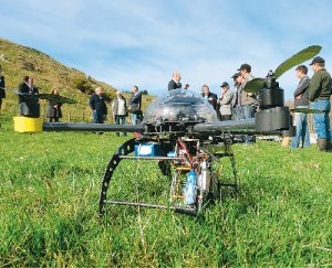
“So these can be mounted on aircraft or on some model helicopter platforms. There are all sorts of off-the-shelf sensors that are available for that sort of application . We are now looking at how we might make that information useful, relevant and valuable for farmers,” he says.
King says it’s not science for science’s sake. It’s applied science of direct benefit to farmers.


