Cyclone Vaianu Brings Heavy Rain, Flooding Across NZ
Cyclone Vaianu is continuing its track south towards the Bay of Plenty, bringing with it destructive winds, heavy rain, and large swells, says Metservice.


 increase font size
 Oahu Point, SH1, north of Kaikoura. Photo: NZ Transport Agency.
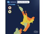
Severe weather is expected to hit New Zealand later today, including a number of areas affected by this morning's earthquakes, the MetService warns.
Severe weather warnings have been issued for strong winds and heavy rain developing this evening in central New Zealand, with gusts up to 140km/h expected in exposed places.
“An active weather system is approaching the lower South Island, with a wedge of warm air from the tropics bringing heavy rain with it. Rain is expected to be heaviest in northwest Nelson, Buller and Westland, and also in the ranges of Marlborough Sounds, Taranaki, Tararua Ranges and the headwaters from Whanganui to Ruapehu,” the MetService says.
Localised downpours are possible, with a high risk of thunderstorms on the West Coast of the South Island this evening until early Tuesday morning. Areas in the east, including Kaikoura, will miss the worst of this rain although scattered falls are likely there overnight before clearing in the morning.
Northerly winds will pick up this afternoon ahead of the system,reaching severe gale in Cook Strait this evening. The strong northerlies will affect areas from Whanganui and Manawatu to Kaikoura, although the strongest gusts will be closer to the Strait, including Wellington where the quake clean-up is underway. Winds should peak in the Kaikoura area tonight before easing into Tuesday morning, although the week ahead will often be windy.
With a full moon tonight, tides will be high and flooding is possible,especially in the Nelson area around tonight's high tide at 10.30pm which coincides with strong onshore winds and heavy rain. Areas on the Kapiti Coast and northern parts of the South Island's West Coast should also beware of high wind waves during tonight's high tide. Heavy rain could also lead to localised flooding tonight in those areas of the upper South Island that are under severe warnings and watches for rain.
The rest of the week is marked by troughs from the Tasman bringing strong winds and rain, especially in the west, although the wet week should ease up by Friday.
Cyclone Vaianu is continuing its track south towards the Bay of Plenty, bringing with it destructive winds, heavy rain, and large swells, says Metservice.

The government has announced a major restructuring of the country's seven crown research institutes (CRIs), which will see them merged into three public research organisations (PROs).
Merging MetService and NIWA is the right thing to do, but independent weather forecaster Phil Duncan of WeatherWatch says he isn’t sure a merged entity will boost rural weather forecasting.
MetService meteorologist James Millward says the country’s weather patterns are now on a much more even footing.
Metservice meteorologist James Millward says the country’s weather patterns are now on a much more even footing.


The managing director of a company seeking to build a solar farm in Canterbury says receiving fast-track approval is a “really positive outcome”.

Retiring MP and dairy farmer Mark Cameron is blasting the Green Party for proposing to ban the use of synthetic fertiliser and cutting cow numbers.
A huge reduction in ACC claims from on-farm accidents over the last five years is due to thousands of small, practical decisions being made in sheds, yards, paddocks and around kitchen tables across the country, says Safer Farms ambassador Lindy Nelson.
Wayne and Ange Moxham of Horowhenua have just been named as Fonterra's top organic performer for milksolids. As well as providing organic milk to Fonterra, the couple also sell Udderly Organic milk to more than 100 outlets in the region and are embarking on another exciting venture producing organic gelato. Reporter Peter Burke went along to see their farming operation.
Certainty and a clear understanding of the needs of rural communities is a critical outcome in the series of government reforms that are taking place at present.
Fonterra has reduced its forecast 2026/27 Farmgate Milk Price.


OPINION: Central Hawke's Bay farmer Mark Warren recently told the Hawke's Bay Times it's time for a conversation about allowing…
OPINION: A nation that relies as heavily as NZ does on functional global shipping lanes will have to do its…
![]()