After a fairly typical first half of spring there has been a noticeable change in the weather across much of New Zealand.
Occasional frosts were recorded in most regions through September and into early October. A more unsettled period from mid-October has been quite eventful, with a severe frost in Central Otago on the first weekend in November following a cold southerly outbreak. Rain has been more frequent in other regions, with mean temperatures pushing above average across most of the country. For much of 2024 sea surface temperatures have been indicating a return of La Niña, which would bring higher humidity and an increase in northeast winds. Current weather patterns have shown less certainty and it is now more likely that early 2025 will bring either a weak La Niña or neutral phase. La Niña also has a historical trend of increased tropical cyclone activity north of New Zealand late in summer and the possibility of a humid and wet period of weather early in 2025 is something to watch out for.
A short history of frost during summer:
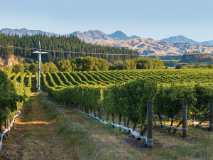
Frost fans and helicopters were busy across much of Marlborough on 17 November and although it is getting late in spring for frost, it is worth noting that much of the South Island and even parts of the lower North Island are susceptible to frost right through summer. The next few months are expected to be mild once again and the risk of frost is very low for the summer ahead. Even though frost can be very low on the priority list it shouldn’t be discounted, especially in the South Island and lower North Island.
During summer many of the risk factors for frost still exist. A cold southerly change can be followed by clear dry air that allows the air to cool quickly. Sub-polar airmasses can be launched northwards over New Zealand with upper air temperature similar at times to a winter outbreak. One factor that can prevent temperatures from falling to freezing is the length of daylight. During late winter and early spring the length of daylight and available heating from the sun is significantly less than late December or early January. For example, Blenheim has 12 hours between sunrise and sunset on 1 September and more than 15 hours of available daylight by the first week of December. The period of time where temperatures are able to cool is reduced. During early spring other risk factors such as cloud cover, upper level humidity, dew points and wind speed all have some influence on night time temperatures. By December all of these factors would need to align to create a significant risk of frost. Central Otago is well-sheltered from the influence of the oceans and being further south has the highest risk of frost during summer. There have been historical examples of temperatures falling below freezing during all months of the year. A recent example was a temperature of -0.1°C recorded near Cromwell on 1 January 2019. The irony being that January 2019 was one of the warmest on record for Central Otago. In Blenheim the mercury dropped to 1.3°C on 23 January 2012.
Historical datasets from NIWA reveal December and January frosts occur over sheltered parts of the lower South Island on a relatively frequent basis. Temperatures below 1°C have been recorded during summer almost every year and several summer frosts were observed, mostly over the lower South Island. Long term temperature records reveal frost or near frost during summer months across some parts of the North Island as well. These cold summer mornings are becoming less frequent though, as our climate continues to warm.
Outlook for December and January:
Gisborne/Hawke's Bay
Temperatures are likely to continue to run above average through early and mid-summer. Night time minimums may run well above normal and humidity is likely to be higher at times making for a few uncomfortable days. The increased frequency of northeasterlies may mean a few cloudier days and this could keep sunshine totals close to average.
Wairarapa
Above average temperatures are expected with mild northerly winds. Winds may be lighter than usual at times as northwesterlies become less frequent. Rainfall may be near average through the first half of summer. Sunshine totals are likely to be near average also.
Nelson
Temperatures continue to run above average for much of summer. Rainfall may be mixed with dry periods especially through December. With an increased chance of low pressure activity later in summer there is the risk of rain events bringing occasional heavy rain.
Marlborough/North Canterbury
Temperatures remain above average through early summer. Occasional northwesterlies may bring a few 30C days, but maximum temperatures may be tempered a little by cooler onshore northeasterlies along the coast. Sheltered inland areas could become very mild at times by early January. Rainfall totals are likely to run close to average but could stay below average through December.
Central Otago
Temperatures are pushing above average. Light northerly airstreams are likely to contribute to warm day time temperatures from mid-December onwards. Rainfalls total are likely to run below average under a predominant northerly flow.
James Morrison runs Weatherstation Frost Forecasting: weatherstation.net.nz


